Monday 3 August 2020
Braerich
Haven't posted anything in ages, all the lockdown inactivity had me quite down. Getting out again feels weird, never sure what kind of reception I'll get. So far it has been good, maybe there's less of the stay away mentality than the press would have us believe.
I've been cycling quite a bit, some quite long day rides up to 80km (50 miles). I'd hoped to do a small tour around the Cowal Peninsular but the week I had off work for it, it rained all the time.
I've also got a new camera a GoPro, the video above is my first attempt. The sound wasn't a great success, couldn't hear anything I said due to the wind noise. I've put some music over it to drown out the racket. Now I'm not sure which is worse, the wind noise or the music.
Tuesday 3 March 2020


Saturday 26 October 2019
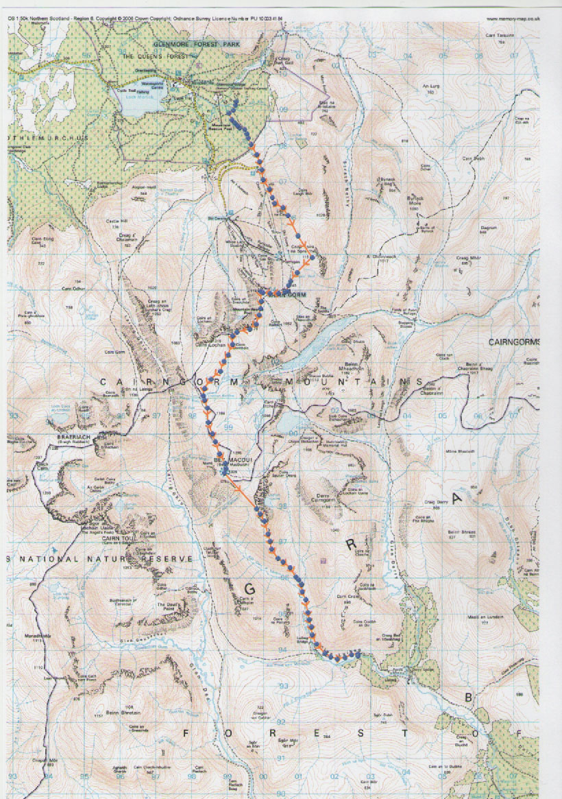
Ben to Ben (Macdui to Nevis)
I had to cut short my last backpacking trip due to my ankle and knee,
now they're a bit more healed I went back to finish my route. Last
time I'd walked from the bus stop in Aviemore all the way up to
Cairngorm summit. I felt it would be more than a little pedantic to
repeat this, so this time I caught the bus up to the ski centre and
started from there. It seems Cairngorm Mountain, or what ever they're
calling themselves this week, have hired a “meet and greet man”
all dressed up in green tweeds. Everyone was ignoring him, I felt
sorry for him, he must have been desperate for work, but I also just
walked on by. The wind was howling and it was drizzling on and off,
it was past 15.00 and I wanted to find somewhere to camp. I'd
originally thought of the top of Lurcher's Gully, but that would be
very exposed in this wind. I wandered into Coire an Lochan and found
a spot tucked under the ridge that was both level-ish and flat-ish
but most importantly dry.

Like most people, I'd imagine, I have my little routines and rituals,
places where things go and orders of doing things. Put the tent up,
fetch water, pull out stuff you need and put it into the tent.
Everything else stays in the rucksack which goes in one vestibule
under the fly. In the other one goes the kitchen etc. I pull off my
boots and dive in and start to get organized, something is missing?
My kindle. I'd even downloaded half a dozen books to read. “Oh
Bugger”. I use the phone to message my brother and sister via the
inReach, then turn off the inReach. Then I notice I have an internet
signal. I surf the net for a bit, a friend is cycling from Roscoff to
Constanta on the Black Sea. He's publishing video blogs as he goes so
I watch a few. He did ask me if I wanted to go with him, after
watching his videos I'm beginning to wish I'd gone.
Wind and rain buffeting the tent all night didn't make for a restful
time, sometime early morning I thought I heard voices. Once awake I
couldn't get back to sleep so I got up and ready. Up the ridge that
makes the western side of the coire, and over a shoulder of Cairn
Lochan to Lochan Buidhe. I found a black fleece jacket laying on the
ground. I look at it but decide it's too heavy to carry and anyway I
don't want another fleece. Further along I meet a man who asks me, in
Spanish, if I'd seen his jacket. When I answered, in Spanish, that I
had and told him where, he seemed amazed. It just struck me as a very
bazaar conversation. There were a few folk around on the summit, a
young lad who'd spent the night by Loch Etchachan and three lasses in
fell running kit ran up and then ran off again. Last time I'd
descended from here by the Sron Riach ridge down to the south, then
walked all the way around to the Lairig Ghru. I'd realized that there
was another shorter way, via the Tailors Burn (Allt Clach nan
Taillear). I'd never walked this path but knew it as an exciting off
piste ski run. The path sticks closely to the burn, it's a good if
steep way down, I wouldn't like to walk up it mind.
Once in the Lairig Ghru I crossed the Dee by the bridge at Corrour
and stopped at the bothy. There's a bloke putting up a tent in front
of the bothy and a girl putting one up at the side. There's also two
girls dressed in running kit sitting on the door steep one appears to
be strapping up the other girls feet. I put down my pack and get out
a biscuit and in a nanosecond we're all mobbed by midgies. All five
of us dive into the bothy and slam the door shut. Once we'd wafted
the midgies away we all settle down to eat. The single girl is
French, about twenty with long blonde dreadlocks, nose rings and very
tanned. The other two girls are from Banchory and have come to “do”
the ridge above, they are going far too slow though. The guy is like
me an old grey beard, he's fussing around the French girl trying to
impress her, quite funny really. After eating I prepare myself for
going out. Head and hands smothered in smidge, wind shirt done up to
the neck. Wide brimmed hat and head net on. Outside not a single
midge.
I plod up the track into Coire Odhar, first the two girl runners pass
me, I hear them talking as they come by their bitching about the
French girl. Then the old guy and the French girl, he tells me their
going to the Devil's Point (Bod an Deamhain – it actually
translates as the Devil's penis but don't tell Queen Victoria). I
plod on, they having just light day packs soon leave me behind.
Eventually, I get to the col, the Devil's Point being on my left, I
look but can't see anyone, I head on to Cairn Toul, to me right. Near
the top I meet the old man.
“I just remembered I need to do the Devil's Point” he says.
“Oh, where's the girl?”
“Oh she's gone on, bloody hell, she's fit”.
I did have a chuckle to myself.
“So, she's gone on to Braeriach, and then back to the bothy?” I
ask.
As it was already late afternoon and that's a long way I was quite
impressed.
After Cairn Toul I dropped down to the start of the Allt clais an
t-Sabhail stream and search out a leave, flat and dry spot to pitch
up for the night. This is where I'd broken off my walk back in April
and now I felt I was really back on track. As the wind had once again
picked up I put out all the guys on the tent. I'm glad I did as it
went from windy to howling gale very quickly after that. Around
midnight the rain came, with the wind and rain hammering away on the
tent I didn't get much sleep again. I put off getting up in the hope
of an improvement but it never came. Eventually, I packed everything
and wriggled into full body armour before crawling out. All I had to
do was drop the tent and roll it up before getting going.
First I went uphill again to the main ridge and followed it over
Angle's Peak (Sgor an Lochain Uaine) to Carn na Criche. From here I
just followed the slope downhill to the south-west until I could see
Loch nan Cnapan sitting in the middle of the Moine Mhor, the huge
expanse of peat moor that lays to the west of the main Cairngorm
mountains. I pass the Loch and just beyond it crossed a stream, the
Allt Sgairnich – this flows away to the south and becomes the River
Eidart itself a fantastic walk, but today I'm heading west. On the
far bank is a jeep turning circle and a track that goes all the way
down to Glen Feshie. I don't like estate roads, they shouldn't be
there and their a horrible surface to walk on. But they are the
quickest way across boggy moor and today it means I can just pull my
hood a bit tighter, switch off my brain and plod on without having to
think too much about navigation. The route the track takes down off
the Moine Mhor is down a ridge between the Allt Garbhlach which flow
out of a very steep sided coire and the Allt Coire Chaoil to the
south. It goes straight down the hill and it's uncompromising and
brutal, by the time I'd gotten down to the valley my thighs were
burning. Over on the other side of the Feshie I could see my route
out of the Glen, again another estate road and again just as brutal.
With that knowledge and the weather it was an easy decision to stop
at the Ruigh Aitechain bothy on the banks of the River Feshie.
There was an old dishevelled looking guy outside the bothy chopping
wood as I approached. I asked “How many people were staying at the
bothy”?
“You should have been here last night, there mush have at least
twenty of um”.
“Yes but how many are here now”?
“DofE group running wild they were”.
“Are they still here”?
“Oh no, they've gone”.
“So, how many are here then”
“Oh, just me and a lass”
The “lass” Jacky, it turns out is also walking from Aviemore to
Fort William only she's going via as many bothies as she could, or so
it seemed. She was taking eight weeks to do the walk, I had eight
days. She was trying to dry off her boots and other kit by a rather
small and inadequate log burner. She said she'd tried to wade across
the Feshie in her flip-flops but had lost her nerve and turned back.
This was worrying news as I also needed to cross the river. Up to a
few years ago there was a footbridge nearby but it was washed away in
a flood. The Dutch owner of the Feshie Estate had a new one made.
This one was made so as to be higher – so it didn't get washed away
again, and it was also wider so he could drive over in his Landrover.
The Cairngorm National Park didn't like this and refused planning
permission, so now it sits useless on the far bank.

Next morning Jacky and I set off to find a way over the river. About a kilometer south of the bothy where the river is spread out into several braids we waded across, none of the braids were anymore than knee deep, a bit of an anti-climax. Once across it was just a question of following the steep uphill track. At the top as it levels out onto the plateau we past a Lochan and were surprised to find a lorry trailer and a large digger. I'd seen quite a few other digger dotted around the hills the day before and more were to follow. At the moment land owners don't need planning permission for building hill tracks. Several major conservation groups are lobbying hard to have this changed. It would seem that there is something of a bonanza to get as many hill tracks built before the change in the law comes. At this point the track enters a spruce plantation, it's marked on the map as a footpath but it's now a brand new very wide gravel road. A few hundred meters further in to the wood it came to an abrupt end. They'd been harvesting the trees, the machines had churned up the ground into a hellish quagmire. Tree stumps and piles of brash lay all over the place. Maybe we should have gone back and walked around the wood but nobody likes backtracking. So we fight our way through. Climbing over, under and around. Slipping sliding and falling all over the place. It takes us well over an hour to cover just two kilometers.
Still at least the weather was nice, the rain and wind had stopped
in the night sometime and now the clouds were beginning to break up
and the sun was beginning to shine. At the far side of the wood we
finally find some semblance of calm. Now we have the opposite problem
- no track. There was no sign of the footpath marked on the map but
as it lead down slope to the burn it wasn't much of a problem.
Gradually as we followed the Allt Bhrun a path began to emerge from
the bog. We crossed over to the western bank by a weir and picked up
an estate road which made the going quicker if less enjoyable.
Further downstream still, another stream flows into the Bhrun, the
outflow from Loch an t-Seilich and another track follows the stream.
This one leads to Gaick Lodge at the far end of the Loch. There's a
bothy at the lodge and this is where Jacky is heading. We say our
goodbyes and she goes off south while I continue north.
At Bhrun cottage there's a bridge marked as being up stream of the
cottage. I didn't find a bridge here only a ford, it wasn't until I
walked downstream past the cottage that that I saw the bridge,
downstream of it. It wasn't as though my boots were dry anyway.
There's one track marked on the map, there are three new ones on the
ground. I pick the old one going west. It's now sunny and getting
hot, I'm walking along in a T-shirt. As I climb the wind slowly but
surely begins to pick up once again. On top of Clach-mheall Beag
(558m) I try to put on my windshirt but it's whipping around in the
wind so much I have trouble getting it over my head. By the time I
get to Clach-mheall Dubh (619m) I can hardly stand. These two hills
are really just a shoulder of Meall Chuaich (951m) one of the
Drumochter Munro's. On it's north-west side is Loch Cuaich where I'd
planned to camp for the night. From the top of Ciach-mheall Dubh I
can see a line on the hillside below me, at first I don't twig
exactly what it is, it's a fence, a deer fence about eight feet high.
I look for a style but there isn't one. I could climb it but doubt it
will take my weight. On the other side is a dry foot path, this side
is all bog and sphagnum moss. I follow the fence for about three
kilometers before I eventually find a gate down by the shore of the
Loch. Loch Cuaich is less than one and a half kilometers long it lays
south-west to north-east in line with the wind. At the down wind end
there are waves lapping on the shore a couple of feet high, there's
nowhere to shelter from this wind. Below the Loch is a mini-hydro
scheme, by the generator shed is a side stream which looks promising
but turns out to be all waterlogged. From there a concrete aqueduct
take water down to Dalwhinnie, I follow it but the ground is all
boggy and sloping and in sight of the busy A9.
Feeling quite dehydrated I stopped at the petrol station for a large
bottle of pop, some sandwiches and cake. I sat outside on some
benches and was quickly surrounded by about a dozen ducks. “What to
do now?” I asked. “There's no campsite at Dalwhinnie, and it
would be pushing it to pitch up in someone's back garden. It was
17.30 already, the next place I suspected I could find anywhere to
camp would be around Loch Pattack, if it wasn't too windy there, and
that would be a good fifteen kilometers further”. “On the other
hand the Dalwhinnie Motal was offering rooms for £35 for the night”.
The duck's just looked at me like I was quackers. Motal rooms are not
really my style so I shouldered my pack and set off.

Signs all around the train station warn anyone even thinking of parking that the estate is harvesting timber and needs access twenty-four, seven. Not sure that's strictly legal on a public road. Beyond the level-crossing it is definitely private land, here the tarmac ends and gravel takes over. The road runs for miles down the length of Loch Ericht, about a kilometre from the start of the Loch is a fairytale Disney-esque gatehouse complete with towers, spires and battlements. The peasantry are directed around by a side gate. To the left of the track the ground slopes down steeply to the Loch, to the right it rises up steeply and is covered in a dense spruce plantation. Thirty years ago there was government subsidy for planting spruce trees, these trees are now ready for harvesting. This is why there's so much forestry activity in the Highlands at the moment. It's late so all the workers have gone home but their machines are parked up at intervals all the way along the Loch. At a small bay half way down the Loch is another Disney-esque gatehouse . Beyond along the shore are yet more buildings in the same style, a chapel, a third gatehouse and out of sight further along is the main “house”. It's a mock French château complete with giant boathouse and heliport. No accounting for taste is there?

Ben Alder.
Some pretty impressive electronic security surround this part of the
estate, the main road goes off left still following the shore. The
hoi-polloi are again directed around the back. On one side of the
track are some lovely old Caledonia Pines but their on a very steep
slope. The other side is flatter, here the trees are spruce in
regimented tightly packed rows. I tried at half a dozen places to
find a suitable camping site but the ground is all chewed up humps
and hollows left by the forestry plough. Finally I find somewhere,
with a bit of clearing, just big enough to fit in my tent. The only
stream nearby is manky so I have to wait twenty minutes longer while
it filters. Twenty minutes is a loooong time when you're gagging.
Before I've finished cooking it's dark – dark! What's that all
about, I haven't seen dark for months. Where's my headtorch? Luckily
I had remembered it. Sometime in the night it rained heavily but it
stopped around dawn. The wind however hasn't stopped, it still bends
and distorts the tent, shaking it violently even though I'm
surrounded by trees. A flash of orange catches my eye, a lady
mountain biker on the track outside the wood. “She's up early, time
to get going”. A good stalkers path follows the Allt á
Chaoil-reide, the river that drains the east side of Ben Alder. It
take me past the old Culra bothy, five years ago when I was last up
this way there was a sign on the door that said that plans were under
way to demolish and replace the bothy. Since then it's had a coat of
paint, it's still closed due to the presence of asbestos, it hasn't
been replaced.
Two short ridges descend from
the high plateau that makes the summit of Ben Alder, the short and
the long Lethchois ridges. I've done the short ridge, a fairly easy
if steep scramble. I had it in mind to do the long ridge this time.
The path leaves the river and begins to climb straight up hill by
this time I'm getting very aware just how strong the wind is.
Suddenly a stronger gust picks me up and drops me face down. I pick
myself up and carry on, a few minutes later the same thing happens. I
pick myself up again, sit down and have a little think. Maybe going
on to the summit today wasn't such a good idea, fortunately I had a
plan B. I retraced my steeps back to the stream and crossed it. On
the other side another well made stalkers path followed the river up
through a small gorge to the Bealach Dubh (the Black Pass). This lays
between Ben Alder to the south and Geal-Charn to the north. On the
other side a long wide valley lead away to the distant Loch Ossian.
The path stays high and contours around the side of Ben Alder – the
left side as I was looking. It crosses another Bealach this time
between Ben Alder and Ben Cumhainn, it then follows the Alder Burn
down to the haunted Ben Alder Cottage on the shore of Loch Ericht.
That wasn't where I was heading this time. Unfortunately between the
path I was stood on and the one I wanted there was several kilometers
of very wet squelchy peat bog.
There was nothing for it except
to plod on. I dropped down to the valley floor, crossed yet another
river before beginning an endless succession of climbing up one peat
hag only to immediately jump down into the next grough and then
climbing up again. Trying to determine whether a piece of ground is
wet or saturated, firm or a bottomless quagmire by the subtle changes
in shades of green or type of plant. A couple of kilometers into
this bog a figure appears coming the other way. He informs me that
two large groups of DofE students along with their handlers were
following on behind him. He also said the YHA on Loch Ossian was open
and most likely to have space as he and the other DofE staff had just
vacated it. The nearer to the loch I got the better the path became
until it morphed into yet another gravel road by a micro hydro scheme
just above the loch. The road lead around the big house on the end of
the loch, Corrour Lodge. This seems to have a large stone tower like
something off the “Fortress Europe” defences. I take the road
around the south shore past some old chalets and through a dark
plantation. Somewhere off in the woods the sound of sporadic shotguns
but I didn't see the shooters. A woman popped out of the hostel as I
approach, and “Yes she has spaces for the night”. The old wooden
building feels more like a Scandinavian hut than a traditional YHA
establishment. It also has hot showers thanks to solar power.
I'm up early to a beautiful day,
no wind and the clouds quickly dissolving in the sun. There's no need
to rush, as I don't have far to go, but it's far too nice a day to
spend it indoors. I pass the turn for Corrour Station, the old
station building are gone as has Morgan's old house. In it's place a
new building, it was an independent hostel for a while but it's now a
pub come restaurant. Apparently it's quite the thing to come up on
the train from Fort William for a meal before getting the train back.
Who'd have thought a pub in the middle of Rannoch Moor would have
worked. I made my way down to Loch Treig, they must have been drawing
power as the “tide” is out. By the shuttered Creagquaineach Lodge
the gravel road finally runs out and the path returns. The Lairig
Leacach path follow a river up stream first through a beautiful mini
gorge then across open moors with Rowen trees in berry and Dippers
dipping. By mid-day I'm at the bothy, I could have gone on but it's
the obvious place to stop and for starting the next leg of my walk. I
chat to a passing walker and a couple retrieveing their mountain bike
parked behind the bothy. The next time I look out it's poring with
rain, “Oh No, will this stop play prematurely”? I got up in the
night to starry sky's.


The main Grey Corries ridge, Ben Nevis on the horizon behind Aonach Beag.
I'm up at dawn and quickly away.
I follow a stream up behind the bothy up into a coire. On one side
the main ridge, on the other sitting out on a limb Stob Ban, a round
dome of a peak. At the col between the two I drop my pack and sprint
up to it's top. I'm back at my pack in just thirty minutes. At 977m
Stob Ban is a Munro but compared to it's neighbours it's a mire
pimple on the end of the giant ridge. I pick up my pack and an hour
later I'm on top of the first of the Grey Corries peaks Stob Choire
Claurigh and looking down into the huge coire on it's north side. The
floor of the coire is covered in scree and as the rock is Quartzite
it gives the hills around here a grey colour, hence the Grey Corries.
Away seven miles to the west Aonach Mor and Beag with the dark
brooding bulk of Ben Nevis behind. Between us is the sensuous
snaking knife edge ridge. Never once dropping below 900m in all that
length. To the north wide open views across the Great Glen to the sea
beyond. To the south the vast expanse of Glen Nevis and the Mamores.
There's three Munro's and five other summits in all. Although the
north side is steep the south is more gentle and the crest is always
wide enough to walk along. On Sgurr Choinnich I meet a young chap and
him small daughter, she informs me that she's “already done
twenty-eight Munro's”. I chat to her dad about the off piste
skiing in the area when we notice she's gone running off along the
ridge. “Look at her” he says, “Seven years old and already I'm
struggling to keep up”. Below Aonach Beag the path runs out
strangely there doesn't seem to be a connection but a scree gully
takes me up onto the upper slopes. It's 18.00 before I make the top
of Aonach Beag and I still need to find a way down. In none of the
guidebooks that I'd looked in could I find any reference to any
connection between the Aonach's and Ben Nevis, which seemed strange
as they're so close. From the col between Mor and Beag I make my way
diagonally down and straight away I'm onto steep unstable scree and
vertical Sphagnum moss. All of a sudden this was beginning to feel
serious. Very slowly I inch my way down, I make it eventually. The
only flat ground is at the col between the Aonach's and Carn Mor
Dearg. The wind which had been building all afternoon was whistling
through the gap with such force there was no way I could pitch the
tent. I had to drop down two kilometers to the north before the wind
had abated enough to camp.
The silence next morning is
strangely reassuring, I rolled out to a white world. The mist clears
as I climb, I'm soon back at the col and a short dry stone wall marks
the way up. I stash the poles and start scrambling, in what seemed no
time at all I'm four hundred metres higher on the summit of Carn Mor
Dearg. All that seperates me from the Ben is a kilometer of knife
edge ridge the Carn Mor Dearg Arete. If you're used to scrambling
it's not hard, you need to use your hands in places but not all the
time. The ground below is sloping scree rather than steep crags so
the exposure isn't too bad and there is a by-pass path on the
south-east side if you need it. But why by-pass all the fun of
balancing along the crest of the arete, even with a big pack on I had
a ball. As I started the arete there had been another party just
finishing. As I finished it yet another party were starting out. As I
climb the scree slope up to the summit of Ben Nevis a guide and two
punters came down. Up to that point seven people was all I'd seen
that day, that was about to change dramatically.

The North face of Ben Nevis with Fort William in the background.
One minute I was all on my own
quietly walking along in the mist the next I was surrounded by
literally hundreds of people. Everywhere you looked there were large
groups of people all crowding around a flag or banner or T-shire all
posing for photo's, whooping and shouting. Everyone was in high
sprites and happy, there was an almost carnival atmosphere. The mist
was trying to lift but I didn't wait for it, if I was quick I could
get the 15.00 bus and get home that night. I started on the trudge
down the yellow brick road that is the tourist route on Britain
highest peak. Coming up was a seeming endless procession of folk,
folk from Germany, France, Spain, Poland, Africa, the middle east and
the Orient, Americans and even a few Scots. There were people in
running kit, people in suits, girls in miniskirts and heels. Perhaps
the most surprising sight was middle aged men – and they were all
were men, dressed head to toe in the latest most expensive outdoor
kit that money could buy. It was all shiny brand new, still spotless
fresh out of the bag. They had the biggest warmest Alpine boots
available La Sportiva Nepal's and the like. The best heavy Gore-Tex
jackets and salopettes I'm sure one even had a down jacket on under
his cag. By this time it was getting hot, most of the walker around
them were like me in T-shirts. But not them, they'd spent all that
money on the best and they were determined to wear it. There were
about seven or eight gentleman so attired and non of them look as if
physical fitness and outdoor activities was their thing.
Once Achintee farm had been just
that a tumbledown old farm house and a lay-by, now there's a
visitor's centre, a pub and a huge car park. Still a larger shandy
went down well. I mist the bus by fifteen minutes but still made it
home that night.
Tuesday 23 July 2019
New Toy!
Since I got back from my backpacking trip in the Cairngorms I've gotten into cycling. At first as exercise for my knee but now I'm really enjoying it. My old bike is one I'd got cheap when Raleigh closed their factory in Nottingham, I think I paid about £100 for it. It's painted to look like a Team Raleigh Banana Bike, but it's not at all high spec even for the 1980's when I brought it. The other night I went out and buckled the front wheel, several other things have gone on it as well. I've been reading about this Ladies adventures in the Finnish Forest. https://livingthislifeoutloudblog.wordpress.com/ Really inspiring stuff. She uses a bike made in Sheffield by a company called Orbit. I've just got one in "Hot Red" looks good.


It came yesterday in a big box, I put it together and went for a short ride. It feels very smooth and surprisingly comfortable after my old bone shaker. I still need to adjust a few things, the front brake rubs for a start.
I've done backpacking and kayak camping as well as just camping for most of my life, so cycle camping is just another angle.
Sunday 19 May 2019
A Cairngorm walk.
I'd
started planning this trip a while ago, then things happened. The
firm I've been working for, for the last eight or nine years, went
bust. I wasn't employed directly by them, I worked for an agency, so
theoretically the agency should have moved me to another firm. Only
they didn't have any other clients. All of a sudden I was getting the
odd shift here and there, maybe one a week maybe none. Then I had a
fall skiing at Cairngorm mountain, I broke a bone in my ankle and my
knee partially dislocated before popping back in, as it did this the
ligaments holding my knee cap in place were sprained and twisted. It
hurt like hell but A&E said there wasn't much they could do, a
plaster cast wouldn't help as the brake was inside the joint. They
said it should heal in four to six weeks on it's own. As I wasn't
getting any work there wasn't much need to take time off, so I sat
around trying to rest my leg getting more and more bored. After three
weeks I started doing some short walks around the local area. Then
some longer walks to nearby villages and finally I went up Ben Lawers
with a rucksack packed for a weekend out. The leg seemed OK. I rang
the agency and told them I was going away for a week. I went online
and booked two bus journeys one to Aviemore and one back from Fort
William, both on my bus pass so they cost me nothing. I packed nine
days food and my kit, then went out for a walk. I hadn't gone far
when the phone rang, it was John Marshall's a firm I'd done a little
work for in the past and had sent a CV to purely on spec. “We're
looking for drivers can you come in and see us.” Yes of course I
could. I went in next day and they offered me a job. I said I had to
work a weeks notice just so I could still get my walk in.


The
plan had been to camp near Loch nan Stuirteag which is behind (west
of) The Devils Point but I could also get there by going the other
way around the mountain. If I went up the Lairig Ghru to Corrour I
could use the bridge so avoiding the river crossing and there's a
path up that side. So that's what I did. Glen Geusachan will just
have to wait. I poked my head around the door at Corrour but
unusually there was no one there. By now the wind had died and the
sun put in a brief appearance so I sat outside and enjoyed my
biscuit. I even went so far as to take off my windproof top, it
didn't stay off long. The climb up into Coire Odher is steep, 600m in
one kilometer. It starts steep, levels out for a while as you enter
the coire then the headwall is very steep. Right at the top was a
patch of snow not very wide but enough to spice things up a bit.
Eventually, breathless and tired, I arrived at the ridge above with
The Devil's Point on one side and Stob Coire an t-Saighdeir and Cairn
Toul on the other. Now I should have gone over Stob Coire an
t-Saighdeir, which is really just a shoulder of Cairn Toul, but I was
lazy and decided to contour around instead, big mistake. It would
have been far easier to have gone over as contouring was far further
and the going was rough on a constant side slope. Once I could see
the loch I could see that all the ground around it was waterlogged
and not good for camping. Fortunately, I knew of a place nearby.
Draining the south west side of Cairn Toul is a stream, the Allt
clais an t-Sabhail along it's length are a few nice places for a tent
or two.


Sunday 24 March 2019
Not posted for ages, not had much to say, not been doing much since August; how has so much time gone by?


Sunday 26 August 2018
Braeriach with the Atompack Prospector Pack.
My new pack finally arrived from Atompacks, it's really nice but ten weeks is a long time to wait. Once it came it seem a shame not to try it out, so on Friday evening I drove up to Aviemore in the pouring rain. Luckily, it stopped before I got there. I parked at Whitewell and headed up Glen Einich, I walked for an hour or so until I came to the edge of the Rothiemurchus forest. Here I camped in what was the worst midgie site I've used for ages. I resorted to a Tiger coil which never fails to clear them out of the tent. It rain all night but had stopped by the time I got up in the morning.


There's a good path from Glen Einich up into Coire Dhondail and up on to the plateau. A short walk up hill took me to the edge of the massive An Garbh Choire. It has been speculated that the last glacier in Britain was in this coire. I'm not so sure, some of the science this claim is based on is decidedly dodgy. It's mainly radio-carbon dating of the lichens on the scree in the coire floor. Still it is a spectacular place.

Carn Toul and Sgor an Lochain Uaine (Angel Peak) from near the Falls of Dee.

My campsite near the Falls of Dee.


Back in the Rothiemurchus forest.
I camped by where the Falls of Dee start, I've used this site before and really like it. I thought "I'll just have a brew and then I'll go up to the summit of Braeriach and take some photo's. By the time I'd finished my tea the mist had descended and I couldn't see more than a few feet.
By morning it was no better and it was raining hard. I had to use my compass to find the way down. I dropped down into the Lairig Ghru and follow the path back into the Rothiemurchus forest and back to the car.
The rucksack was very comfortable and dry inside, has some nice pockets and should be a good size for shorter trips up to about four or five day I think.
Subscribe to:
Posts (Atom)